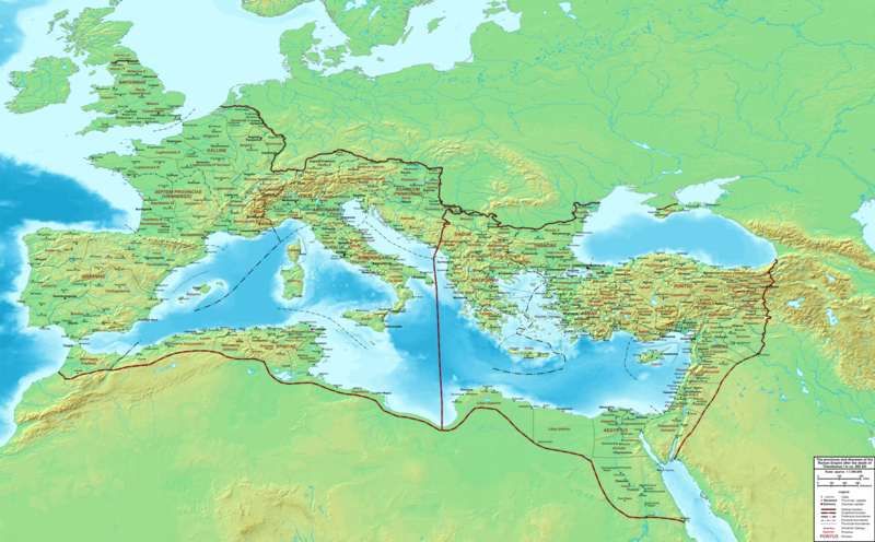
Soubor:The Roman Empire ca 400 AD.png

Velikost tohoto náhledu: 800 × 496 pixelů. Jiná rozlišení: 320 × 198 pixelů | 640 × 397 pixelů | 1 024 × 635 pixelů | 1 280 × 793 pixelů | 2 560 × 1 587 pixelů | 4 339 × 2 689 pixelů.
Původní soubor (4 339 × 2 689 pixelů, velikost souboru: 12,8 MB, MIME typ: image/png)
Historie souboru
Kliknutím na datum a čas se zobrazí tehdejší verze souboru.
| Datum a čas | Náhled | Rozměry | Uživatel | Komentář | |
|---|---|---|---|---|---|
| současná | 20. 2. 2015, 00:27 |  | 4 339 × 2 689 (12,8 MB) | Cplakidas | added potential location of Valentia beyond Hadrian's Wall, removed provincial boundaries in Britannia as too tentative |
| 21. 7. 2011, 15:03 |  | 4 339 × 2 689 (10,9 MB) | Cplakidas | fixed Persian border, differentiated between Eastern and Western empire, different borders for praet. prefectures | |
| 21. 3. 2009, 04:37 |  | 4 475 × 2 600 (9,99 MB) | Cplakidas | minor corrections | |
| 29. 5. 2008, 14:30 |  | 3 800 × 2 370 (8,1 MB) | Cplakidas | ||
| 29. 5. 2008, 14:17 |  | 4 560 × 2 850 (11,22 MB) | Cplakidas | clearer version & addition of the Armenian satrapies | |
| 30. 12. 2007, 04:02 |  | 3 380 × 2 120 (5,96 MB) | Cplakidas | added names of dioceses, legend box, various minor adjustments | |
| 13. 12. 2007, 16:27 |  | 3 550 × 2 200 (6,65 MB) | Cplakidas | new improved version made with Inkscape, slight corrections in borders, added several cities in Africa & Spain | |
| 12. 11. 2007, 21:27 |  | 3 550 × 2 200 (4,75 MB) | Cplakidas | minor corrections in southern Gaul | |
| 5. 11. 2007, 14:58 |  | 3 550 × 2 200 (4,75 MB) | Cplakidas | New version, with some corrections & additions | |
| 31. 10. 2007, 18:55 |  | 3 436 × 2 142 (4,5 MB) | Cplakidas | {{Information |Description=Map of the Roman Empire ca. 400 AD, showing the administrative division into dioceses and provinces, as well as the major cities. The demarcation between Eastern and Western Empires is noted in red. |Source=Base map found at |
Využití souboru
Tento soubor používají následující 2 stránky:
Globální využití souboru
Tento soubor využívají následující wiki:
- Využití na af.wikipedia.org
- Využití na ar.wikipedia.org
- Využití na ary.wikipedia.org
- Využití na ast.wikipedia.org
- Využití na bg.wikipedia.org
- Využití na bn.wikipedia.org
- Využití na ca.wikipedia.org
- Využití na ceb.wikipedia.org
- Využití na de.wikipedia.org
- Využití na el.wikipedia.org
- Využití na en.wikipedia.org
- Využití na eo.wikipedia.org
- Využití na es.wikipedia.org
- Využití na et.wikipedia.org
- Využití na fr.wikipedia.org
- Využití na he.wikipedia.org
- Využití na hi.wikipedia.org
- Využití na hr.wikipedia.org
- Využití na hu.wikipedia.org
- Využití na id.wikipedia.org
- Využití na it.wikipedia.org
- Využití na ko.wikipedia.org
- Využití na la.wikipedia.org
- Využití na lt.wikipedia.org
- Využití na nl.wikipedia.org
Zobrazit další globální využití tohoto souboru.


