
Soubor:Serbia drainage basins detailed.png

Velikost tohoto náhledu: 398 × 599 pixelů. Jiná rozlišení: 159 × 240 pixelů | 319 × 480 pixelů | 850 × 1 280 pixelů.
Původní soubor (850 × 1 280 pixelů, velikost souboru: 317 KB, MIME typ: image/png)
| Tento soubor pochází z Wikimedia Commons. Níže jsou zobrazeny informace, které obsahuje jeho tamější stránka s popisem souboru. |
Popis
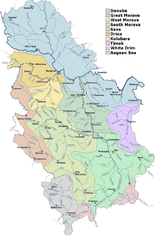
| Popis | Detailed map of rivers and main drainage basins in Serbia. |
| Zdroj | Merged from several images published by Hydrometeorological Institute of Serbia. |
| Autor | HIS |
Licence
This image is in the public domain because according to the Copyright Law of Serbia and Montenegro ("Службени гласник СЦГ", бр. 61/2004), "Work is not copyrighted if the work is:
|
 |
Historie souboru
Kliknutím na datum a čas se zobrazí tehdejší verze souboru.
| Datum a čas | Náhled | Rozměry | Uživatel | Komentář | |
|---|---|---|---|---|---|
| současná | 6. 11. 2006, 14:01 | | 850 × 1 280 (317 KB) | Duja | ==Description== Detailed map of rivers and main drainage basins in Serbia ==Licensing== Merged from several images published by Hydrometeorological Institute of Serbia , http://www.hidmet.sr.gov.yu/slike_lat/kv_vode/ [[Category:Maps of rivers of Serbia |
Využití souboru
Tento soubor používá následující stránka:
Globální využití souboru
Tento soubor využívají následující wiki:
- Využití na ast.wikipedia.org
- Využití na bg.wikipedia.org
- Využití na bn.wikipedia.org
- Využití na de.wikipedia.org
- Využití na en.wikipedia.org
- Využití na es.wikipedia.org
- Využití na fr.wikipedia.org
- Využití na it.wikipedia.org
- Využití na mk.wikipedia.org
- Využití na nl.wikipedia.org
- Využití na nn.wikipedia.org
- Využití na pl.wikipedia.org
- Využití na ro.wikipedia.org
- Využití na ru.wikipedia.org
- Využití na sh.wikipedia.org
- Využití na sr.wikipedia.org
- Јадар (притока Дрине)
- Списак река у Србији
- Јабланица (притока Јужне Мораве)
- Јадар (област)
- Рибница (притока Ибра)
- Лопатањка (река)
- Рибница (притока Колубаре)
- Фидер риболов
- Бешеновачки поток
- Бруја (водени ток)
- Велики поток
- Врањашки поток
- Думбовачки поток
- Ешиковачки поток
- Јеленце
- Каменарски поток
- Каменички поток
- Козарски поток
- Корушка (водени ток)
- Липовачки поток
- Међеш
- Поток Мохарач
Zobrazit další globální využití tohoto souboru.