Soubor:Satellite View of the Thaw-Lake Plain (3cb35dd0-5a5b-4cd1-9637-99c77958e798).jpg

Obsah stránky není podporován v jiných jazycích.
Z Wikipedie, otevřené encyklopedie

Původní soubor(1 049 × 875 pixelů, velikost souboru: 753 KB, MIME typ: image/jpeg)

Popis

English: Satellite View of the Thaw-Lake Plain
Fotograf
English: NPS
Název
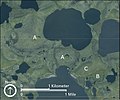
English: Satellite View of the Thaw-Lake Plain
Popis
English:

: Satellite photograph of a plain with several lakes and distinct rounded features, labeled ‘A,’ ‘B,’ or ‘C.’

"A"s mark old thaw lakes that drained and permafrost re-formed (note the polygons), resulting in a pingo in the center. "B" marks a recently drained thaw lake; it drained to the southwest into the bigger lake, but only partly so some water is still left. "C" marks remnant yedoma.

Depicted place
English: Bering Land Bridge National Preserve, Alaska
Inventární číslo
Zdroj
English: NPGallery
Svolení
(Užití tohoto souboru)
Public domain This image or media file contains material based on a work of a National Park Service employee, created as part of that person's official duties. As a work of the U.S. federal government, such work is in the public domain in the United States. See the NPS website and NPS copyright policy for more information.
NPS Unit Code
InfoField
BELA

Popisky

Přidejte jednořádkové vysvětlení, co tento soubor představuje

Položky vyobrazené v tomto souboru

zobrazuje

Historie souboru

Kliknutím na datum a čas se zobrazí tehdejší verze souboru.

Datum a časNáhledRozměryUživatelKomentář
současná14. 1. 2022, 06:29Náhled verze z 14. 1. 2022, 06:291 049 × 875 (753 KB)BMacZeroBotBatch upload (Commons:Batch uploading/NPGallery)

Tento soubor používají následující 4 stránky:

Globální využití souboru

Tento soubor využívají následující wiki:

Metadata