
Soubor:Periplous of the Erythraean Sea.svg

Velikost tohoto PNG náhledu tohoto SVG souboru: 800 × 564 pixelů. Jiná rozlišení: 320 × 226 pixelů | 640 × 452 pixelů | 1 024 × 722 pixelů | 1 280 × 903 pixelů | 2 560 × 1 806 pixelů.
Původní soubor (soubor SVG, nominální rozměr: 1 280 × 903 pixelů, velikost souboru: 1,39 MB)
| Tento soubor pochází z Wikimedia Commons. Níže jsou zobrazeny informace, které obsahuje jeho tamější stránka s popisem souboru. |
Popis
| Popis |
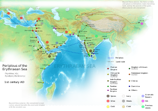
English: Periplous of the Erythreaen Sea map, according to the description from source text (https://el.wikisource.org/wiki/Περίπλους_τῆς_Ἐρυθράς_Θαλάσσης). Original names have been transcribed to Latin alphabet when possible. For the Greek names look at the respective Greek version of the map.
Ελληνικά: Χάρτης του περίπλου της Ερυθράς Θαλάσσης(Αγγλική έκδοση), σύμφωνα με την περιγραφή του κειμένου (https://el.wikisource.org/wiki/Περίπλους_τῆς_Ἐρυθράς_Θαλάσσης). हिन्दी: एरिथ्रेअन सागर के पेरिप्लस के नाम, मार्ग और स्थान
Català: Mapa del Periple de la Mar Eritrea, segons la descripció de la font (https://el.wikisource.org/wiki/Περίπλους_τῆς_Ἐρυθράς_Θαλάσσης). Els noms originals s'han transcrit a l'alfabet llatí quan ha estat possible. Per als noms grecs mireu la versió grega del mapa. |
| Datum | |
| Zdroj | Vlastní dílo |
| Autor | George Tsiagalakis |
| Svolení (Užití tohoto souboru) |
Mention author and licence when using this work, e.g. "George Tsiagalakis / CC-BY-SA-4 licence" |
| Další verze |
|


Tento vektorový obrázek byl vytvořen programem Inkscape .

|
Tento soubor ve formátu SVG obsahuje vložený text či texty, které lze přeložit do češtiny. K překladu je možné použít některé vektorové editory, textový editor nebo nástroj SVG Překladač. Pro více informací navštivte Nápovědu k překladům souborů SVG. |
Licence
Já, držitel autorských práv k tomuto dílu, ho tímto zveřejňuji za podmínek následující licence:
| Multi-licensed with all versions of the Creative Commons Attribution Share-Alike License | ||
| I agree to multi-license my contributions, unless otherwise stated, under the GFDL and the Creative Commons Attribution Share-Alike license version 1.0, version 2.0, version 2.5, version 3.0, and all future versions of the Creative Commons Attribution Share-Alike license. Please be aware that other contributors might not do the same, so if you want to use my contributions under the Creative Commons terms, please check the CC dual-license and Multi-licensing guides. | ||

|
Tento dokument smí být kopírován, šířen nebo upravován podle podmínek Svobodné licence GNU pro dokumenty verze 1.2 nebo libovolné vyšší verze publikované nadací Free Software Foundation. Dokument nemá neměnné části ani texty na předním či zadním přebalu. Kopie textu licence je k dispozici v oddíle nazvaném GNU Free Documentation License. |
This file is licensed under the Creative Commons Attribution-Share Alike Attribution-Share Alike 4.0 International, 3.0 Unported, 2.5 Generic, 2.0 Generic and 1.0 Generic license.
- Dílo smíte:
- šířit – kopírovat, distribuovat a sdělovat veřejnosti
- upravovat – pozměňovat, doplňovat, využívat celé nebo částečně v jiných dílech
- Za těchto podmínek:
- uveďte autora – Máte povinnost uvést autorství, poskytnout odkaz na licenci a uvést, pokud jste provedli změny. Toho můžete docílit jakýmkoli rozumným způsobem, avšak ne způsobem naznačujícím, že by poskytovatel licence schvaloval nebo podporoval vás nebo vaše užití díla.
- zachovejte licenci – Pokud tento materiál jakkoliv upravíte, přepracujete nebo použijete ve svém díle, musíte své příspěvky šířit pod stejnou nebo slučitelnou licencí jako originál.
Historie souboru
Kliknutím na datum a čas se zobrazí tehdejší verze souboru.
| Datum a čas | Náhled | Rozměry | Uživatel | Komentář | |
|---|---|---|---|---|---|
| současná | 29. 9. 2023, 19:48 | | 1 280 × 903 (1,39 MB) | Joutbis | File uploaded using svgtranslate tool (https://svgtranslate.toolforge.org/). Added translation for ca. |
| 29. 9. 2023, 19:33 |  | 1 280 × 903 (1,38 MB) | Joutbis | File uploaded using svgtranslate tool (https://svgtranslate.toolforge.org/). Added translation for ca. | |
| 1. 2. 2023, 23:13 |  | 1 280 × 903 (1,32 MB) | Theklan | File uploaded using svgtranslate tool (https://svgtranslate.toolforge.org/). Added translation for eu. | |
| 9. 1. 2022, 21:12 |  | 1 280 × 903 (1,28 MB) | Mr. Ibrahem | Reverted to version as of 11:44, 6 May 2021 (UTC) | |
| 9. 1. 2022, 15:29 |  | 1 280 × 903 (1,28 MB) | Mr. Ibrahem | File uploaded using svgtranslate tool (https://svgtranslate.toolforge.org/). Added translation for ar. | |
| 6. 5. 2021, 13:44 |  | 1 280 × 903 (1,28 MB) | Andrei Stroe | File uploaded using svgtranslate tool (https://svgtranslate.toolforge.org/). Added translation for ro. | |
| 31. 1. 2015, 18:10 |  | 1 280 × 903 (1,28 MB) | Gts-tg | Small updates in spelling of city names | |
| 31. 1. 2015, 17:39 |  | 1 280 × 903 (1,28 MB) | Gts-tg | More accurate positioning for Nikon(os) and Sarapion(os), corresponding to modern Barawe and Mogadishu respectively. Improved legibility of place names | |
| 29. 1. 2015, 05:15 |  | 1 280 × 903 (1,28 MB) | Gts-tg | Updates as [https://en.wikipedia.org/wiki/User_talk:Gts-tg#Periplus_svg indicated by Wikipedia editors] | |
| 26. 12. 2014, 19:31 |  | 1 280 × 903 (1,28 MB) | Gts-tg | User created page with UploadWizard |
Využití souboru
Tento soubor používá následující stránka:
Globální využití souboru
Tento soubor využívají následující wiki:
- Využití na af.wikipedia.org
- Využití na ar.wikipedia.org
- Využití na arz.wikipedia.org
- Využití na az.wikipedia.org
- Využití na bg.wikipedia.org
- Využití na bn.wikipedia.org
- Využití na ca.wikipedia.org
- Využití na ceb.wikipedia.org
- Využití na da.wikipedia.org
- Využití na de.wikipedia.org
- Využití na el.wikipedia.org
- Využití na en.wikipedia.org
- Arabian Sea
- History of Cambodia
- Foreign relations of Ethiopia
- Red Sea
- Kozhikode
- Kochi
- Malappuram district
- Tamils
- Roman Egypt
- Spice trade
- Trade route
- Bharuch
- History of South India
- Kollam
- Barbarikon
- Hippalus
- Islam in India
- Opone
- Mappila Muslims
- Sino-Roman relations
- Christianity in India
- Timeline of international trade
- Incense trade route
Zobrazit další globální využití tohoto souboru.