
Soubor:Negroland and Guinea with the European Settlements, 1736.jpg

Původní soubor (1 200 × 894 pixelů, velikost souboru: 1,55 MB, MIME typ: image/jpeg)
| Tento soubor pochází z Wikimedia Commons. Níže jsou zobrazeny informace, které obsahuje jeho tamější stránka s popisem souboru. |
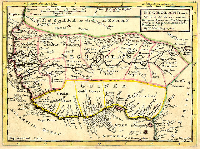
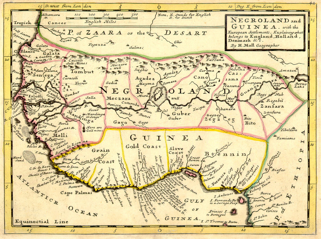
Map|thumb|alt=https://www.canva.com/design/DAEqyLnPwRY/share/preview?token=KSHUFcVdAgta6UUstYCF7w&role=EDITOR&utm_content=DAEqyLnPwRY&utm_campaign=designshare&utm_medium=link&utm_source=sharebutton%7CThis 1747 Map reflects the various Kingdoms. The Kingdom of Juda(h). Ouidah /ˈwiːdə/, also Whydah /ˈhwaɪdə/ ]]
Popis
| Popis | Full title: 'Negroland and Guinea with the European Settlements, Explaining what belongs to England, Holland, Denmark, etc'. By H. Moll Geographer (Printed and sold by T. Bowles next ye Chapter House in St. Pauls Church yard, & I. Bowles at ye Black Horse in Cornhill, 1729, orig. published in 1727). [1] |
| Datum | |
| Zdroj | University of Florida, George A. Smathers Libraries, historic African maps: 1729 Herman Moll (#ALW1663) |
| Autor | Herman Moll |
Licence
|
Toto dílo je volné také v zemích, jejichž právní řád chrání majetková autorská práva po dobu života autora a 100 let po jeho smrti. | |
| Bylo zjištěno, že u tohoto souboru nejsou známa žádná omezení daná autorským právem a právy s ním souvisejícími. | |
Původní historie souboru
(All user names refer to en.wikipedia)
- 2006-06-13 23:18 LIL T 1200×894×8 (1624023 bytes)
Historie souboru
Kliknutím na datum a čas se zobrazí tehdejší verze souboru.
| Datum a čas | Náhled | Rozměry | Uživatel | Komentář | |
|---|---|---|---|---|---|
| současná | 3. 2. 2008, 08:16 | | 1 200 × 894 (1,55 MB) | BetacommandBot | move approved by: User:Dcoetzee This image was moved from Image:ALW1663L.jpg {{Information |Description=Full title: 'Negroland and Guinea with the European Settlements, Explaining what belongs to England, Holland, Denmark, etc'. By [[:en:Herman |
Využití souboru
Tento soubor používají následující 2 stránky:
Globální využití souboru
Tento soubor využívají následující wiki:
- Využití na an.wikipedia.org
- Využití na ar.wikipedia.org
- Využití na ba.wikipedia.org
- Využití na be.wikipedia.org
- Využití na bn.wikipedia.org
- Využití na br.wikipedia.org
- Využití na bs.wikipedia.org
- Využití na ca.wikipedia.org
- Využití na ceb.wikipedia.org
- Využití na cv.wikipedia.org
- Využití na da.wikipedia.org
- Využití na de.wikipedia.org
- Využití na en.wikipedia.org
- Využití na eo.wikipedia.org
- Využití na es.wikipedia.org
- Využití na eu.wikipedia.org
- Využití na fa.wikipedia.org
- Využití na fi.wikipedia.org
- Využití na fr.wikipedia.org
- Využití na fr.wiktionary.org
- Využití na fy.wikipedia.org
Zobrazit další globální využití tohoto souboru.