
Soubor:Mars landing sites 2014.jpg

Velikost tohoto náhledu: 800 × 400 pixelů. Jiná rozlišení: 320 × 160 pixelů | 640 × 320 pixelů | 1 280 × 640 pixelů.
Původní soubor (1 280 × 640 pixelů, velikost souboru: 1,02 MB, MIME typ: image/jpeg)
| Tento soubor pochází z Wikimedia Commons. Níže jsou zobrazeny informace, které obsahuje jeho tamější stránka s popisem souboru. |
Popis
| Popis |
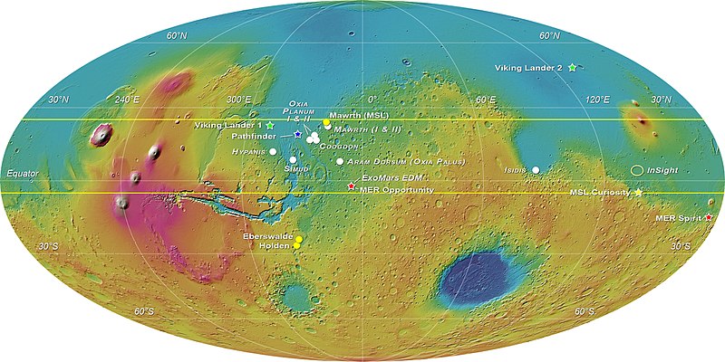
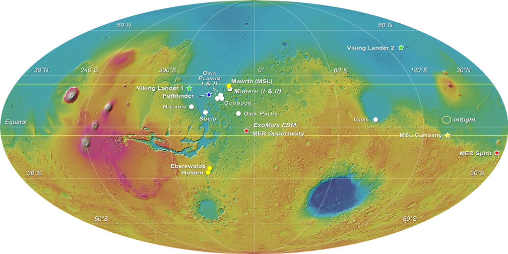
English: MOLA elevation map of Mars with white circles showing the eight landing sites proposed for the ExoMars 2018 mission: Mawrth Vallis (for which 2 proposals were received), Oxia Planum (2 areas were proposed), Coogoon Valles, Hypanis Vallis, Simud Vallis, Oxia Palus and Southern Isidis.
A yellow star marks the position of the Curiosity rover; three other locations that were shortlisted for Curiosity are indicated with yellow circles. Other stars and ellipses are used to indicate past and future missions' touchdown spots. This image was compiled by E. Hauber for the Landing Site Selection Working Group. |
| Datum | |
| Zdroj | http://mars.nasa.gov/multimedia/images/?ImageID=6125 > File |
| Autor | ESA-Roscosmos/LSSWG/E. Hauber |
Licence
| This file is in the public domain in the United States because it was solely created by NASA. NASA copyright policy states that "NASA material is not protected by copyright unless noted". (See Template:PD-USGov, NASA copyright policy page or JPL Image Use Policy.) | ||
 |
Warnings:
|
Historie souboru
Kliknutím na datum a čas se zobrazí tehdejší verze souboru.
| Datum a čas | Náhled | Rozměry | Uživatel | Komentář | |
|---|---|---|---|---|---|
| současná | 25. 11. 2021, 05:54 | | 1 280 × 640 (1,02 MB) | Cherurbino | updated version as of 1 September 2019 from https://exploration.esa.int/web/mars/-/53942-exomars-2018-proposed-landing-sites |
| 10. 3. 2016, 19:13 |  | 1 024 × 512 (114 KB) | BatteryIncluded | User created page with UploadWizard |
Využití souboru
Tento soubor používá následující stránka:
Globální využití souboru
Tento soubor využívají následující wiki:
- Využití na ca.wikipedia.org
- Využití na en.wikipedia.org
- Využití na et.wikipedia.org
- Využití na fr.wikipedia.org
- Využití na gl.wikipedia.org
- Využití na it.wikipedia.org
- Využití na li.wikipedia.org