
Soubor:Map of Washington highlighting Grays Harbor County.svg

Velikost tohoto PNG náhledu tohoto SVG souboru: 800 × 521 pixelů. Jiná rozlišení: 320 × 208 pixelů | 640 × 416 pixelů | 1 024 × 666 pixelů | 1 280 × 833 pixelů | 2 560 × 1 666 pixelů | 5 936 × 3 863 pixelů.
Původní soubor (soubor SVG, nominální rozměr: 5 936 × 3 863 pixelů, velikost souboru: 215 KB)
| Tento soubor pochází z Wikimedia Commons. Níže jsou zobrazeny informace, které obsahuje jeho tamější stránka s popisem souboru. |
Popis
| Popis |
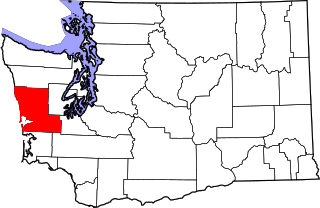
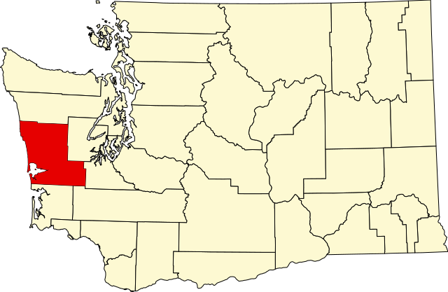
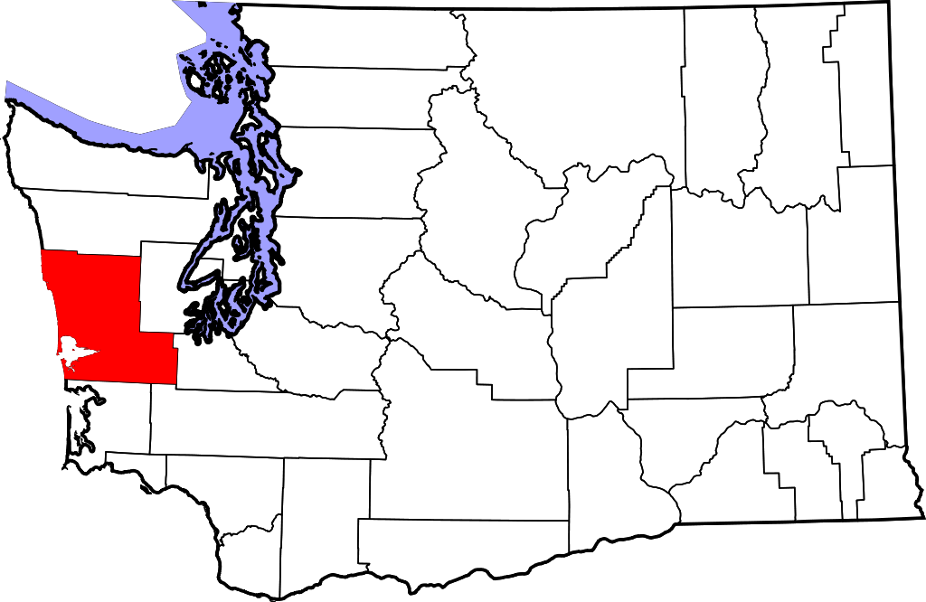
English: This is a locator map showing Grays Harbor County in Washington. For more information, see Commons:United States county locator maps. |
| Datum | |
| Zdroj |
Vlastní dílo: English: The maps use data from nationalatlas.gov, specifically countyp020.tar.gz on the Raw Data Download page. The maps also use state outline data from statesp020.tar.gz. The Florida maps use hydrogm020.tar.gz to display Lake Okeechobee. |
| Autor | David Benbennick |
Licence
| Já, autor tohoto díla, jej tímto uvolňuji jako volné dílo, a to celosvětově. V některých zemích to není podle zákona možné; v takovém případě: Poskytuji komukoli právo užívat toto dílo za libovolným účelem, a to bezpodmínečně s výjimkou podmínek vyžadovaných zákonem. |
Historie souboru
Kliknutím na datum a čas se zobrazí tehdejší verze souboru.
| Datum a čas | Náhled | Rozměry | Uživatel | Komentář | |
|---|---|---|---|---|---|
| současná | 12. 2. 2006, 20:03 | | 5 936 × 3 863 (215 KB) | David Benbennick | {{subst:User:Dbenbenn/clm|county=Grays Harbor County|state=Washington|type=county}} |
Využití souboru
Tento soubor používá následující stránka:
Globální využití souboru
Tento soubor využívají následující wiki:
- Využití na ar.wikipedia.org
- Využití na bg.wikipedia.org
- Využití na bpy.wikipedia.org
- Využití na ca.wikipedia.org
- Aberdeen (Washington)
- Aberdeen Gardens
- Brady (Washington)
- Central Park (Washington)
- Chehalis Village
- Cohassett Beach
- Copalis Beach
- Elma (Washington)
- Grayland
- Hoquiam
- Humptulips
- Junction City (Washington)
- Malone-Porter
- Markham (Washington)
- McCleary
- Moclips
- Montesano
- Neilton
- Oakville (Washington)
- Ocean City (Washington)
- Ocean Shores
- Oyehut-Hogans Corner
- Satsop
- Taholah
- Westport (Washington)
- Plantilla:Comtat de Grays Harbor
- Využití na cdo.wikipedia.org
- Využití na ceb.wikipedia.org
- Využití na ce.wikipedia.org
- Využití na cy.wikipedia.org
- Využití na de.wikipedia.org
- Využití na en.wikipedia.org
- List of counties in Washington
- Grays Harbor County, Washington
- Aberdeen, Washington
- Aberdeen Gardens, Washington
- Brady, Washington
- Central Park, Washington
- Chehalis Village, Washington
- Cohassett Beach, Washington
- Copalis Beach, Washington
- Cosmopolis, Washington
- Elma, Washington
- Grayland, Washington
- Hoquiam, Washington
- Humptulips, Washington
Zobrazit další globální využití tohoto souboru.