
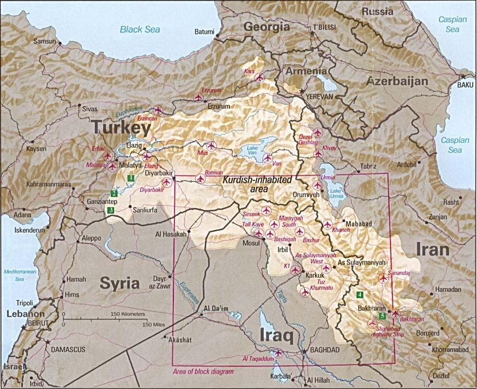
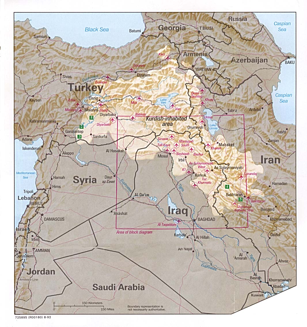
Soubor:Kurdish-inhabited area by CIA (1992).jpg
Původní soubor (982 × 802 pixelů, velikost souboru: 630 KB, MIME typ: image/jpeg)
| Tento soubor pochází z Wikimedia Commons. Níže jsou zobrazeny informace, které obsahuje jeho tamější stránka s popisem souboru. |
Popis
| Popis |
Ελληνικά: Περιοχές κατοικούμενες από Κούρδους κατά τη CIA (1992) |
| Datum | August 1992 or earlier |
| Zdroj |
Perry-Castañeda Library Map Collection at The University of Texas at Austin [1] linked from Perry-Castañeda Library Map Collection at The University of Texas at Austin |
| Autor |
English: Source stated "The following maps were produced by the U.S. Central Intelligence Agency, unless otherwise indicated." The original, non-cropped map also states: "Boundary representation is not necessarily authoritative". |
| Další verze |

.jpg)
Please do not overwrite this file: any cropping or other restoration work should be uploaded with a new name and linked in this page's "other versions=" parameter, so that this file represents the exact file found in the CIA catalog record to which it links. The metadata on this page was imported directly from CIA's catalog record; additional descriptive text may be added by Wikimedians to the template below with the "description=" parameter, but please do not modify the other fields. translate
(Note: Editors who post this notice are strongly encouraged to add details explaining how it applies to this file.)
Licence
| Tento obrázek je dílem zaměstnance Central Intelligence Agency pořízeným nebo vytvořeným během výkonu úředních povinností. Jako dílo vlády USA je tento obrázek nebo médium volným dílem.
|

|
See also
- File:Kurdish lands 92.jpg - cropped and down-scaled version of same map apparently first uploaded at English wikipedia in 12 May 2003 from [2] and transferred to Commons on 2007-09-08
- Image:Kurdish lands 92 cropped.jpg - apparently cropped on 15 Jun 2003 (see w:en:Talk:Kurdish people/Archive 1) moved to Commons on or before 2006-12-16 but deleted on 9 February 2007 with comment: Superceeded ny Image:Kurdish-inhabited area by CIA (1992).jpg
Historie souboru
Kliknutím na datum a čas se zobrazí tehdejší verze souboru.
.jpg&dir=prev)
.jpg&offset=20100807100521)
.jpg&offset=&limit=20)
.jpg&offset=&limit=50)
.jpg&offset=&limit=100)
.jpg&offset=&limit=250)
.jpg&offset=&limit=500)
| Datum a čas | Náhled | Rozměry | Uživatel | Komentář | |
|---|---|---|---|---|---|
| současná | 20. 8. 2010, 09:47 | | 982 × 802 (630 KB) | Sv1xv | Reverted to version as of 18:21, 9 February 2007 |
| 19. 8. 2010, 22:47 |  | 975 × 795 (177 KB) | Saadwand | Reverted to version as of 10:05, 7 August 2010 | |
| 18. 8. 2010, 07:15 |  | 975 × 795 (556 KB) | Kintetsubuffalo | make a new map, stop warring, per discussion | |
| 17. 8. 2010, 22:51 |  | 975 × 795 (177 KB) | Daryai | Reverted to version as of 12:55, 14 August 2010 | |
| 14. 8. 2010, 17:13 |  | 975 × 795 (556 KB) | Kintetsubuffalo | we're not going to edit war on this-create your own map | |
| 14. 8. 2010, 14:55 |  | 975 × 795 (177 KB) | Abuadab | Reverted to version as of 10:05, 7 August 2010 | |
| 13. 8. 2010, 23:48 |  | 975 × 795 (556 KB) | Prosfilaes | It's a CIA map as of 1992; if you want to update it, feel free to copy it | |
| 13. 8. 2010, 22:45 |  | 975 × 795 (177 KB) | Leosan | Reverted to version as of 10:05, 7 August 2010 | |
| 7. 8. 2010, 20:14 |  | 975 × 795 (556 KB) | Kintetsubuffalo | changes fundaments of CIA map for that date. if you want to update, make a new map with a different date | |
| 7. 8. 2010, 12:05 |  | 975 × 795 (177 KB) | Saadwand | River coloured. |
Využití souboru
Globální využití souboru
Tento soubor využívají následující wiki:
- Využití na an.wikipedia.org
- Využití na ar.wikipedia.org
- Využití na ar.wikiversity.org
- Využití na ast.wikipedia.org
- Využití na azb.wikipedia.org
- Využití na be.wikipedia.org
- Využití na bn.wikipedia.org
- Využití na br.wikipedia.org
- Využití na ca.wikipedia.org
- Využití na ca.wikinews.org
- Využití na ce.wikipedia.org
- Využití na ckb.wikipedia.org
- Využití na da.wikipedia.org
- Využití na de.wikipedia.org
- Irak
- Kurden
- Portal:Kurdistan
- Portal:Kurdistan/Willkommen
- Wikipedia:WikiProjekt Kurdistan
- Wikipedia:WikiProjekt Kurdistan/Intro
- Wikipedia:WikiProjekt Kurdistan/Benutzer
- Wikipedia:WikiProjekt Kurdistan/Teilnehmer
- Benutzer:Bohater/ Kurdisch
- Wikipedia:WikiProjekt Kurdistan/Benutzer Box
- Benutzer:Bohater/Spielwiese
- Wikipedia:WikiProjekt Kurdistan/logo
- Benutzer:Projekt-Till/In Memoriam
- Benutzer:Yoda41
- Diskussion:Völkermord an den irakischen Turkmenen
- Využití na dsb.wikipedia.org
- Využití na el.wikipedia.org
- Využití na en.wikipedia.org
Zobrazit další globální využití tohoto souboru.
.jpg)
.jpg)