
Soubor:Ethnographic-map-Thrace-1912.jpg

Původní soubor (3 520 × 2 080 pixelů, velikost souboru: 6,01 MB, MIME typ: image/jpeg)
| Tento soubor pochází z Wikimedia Commons. Níže jsou zobrazeny informace, které obsahuje jeho tamější stránka s popisem souboru. |
Popis
| Popis |
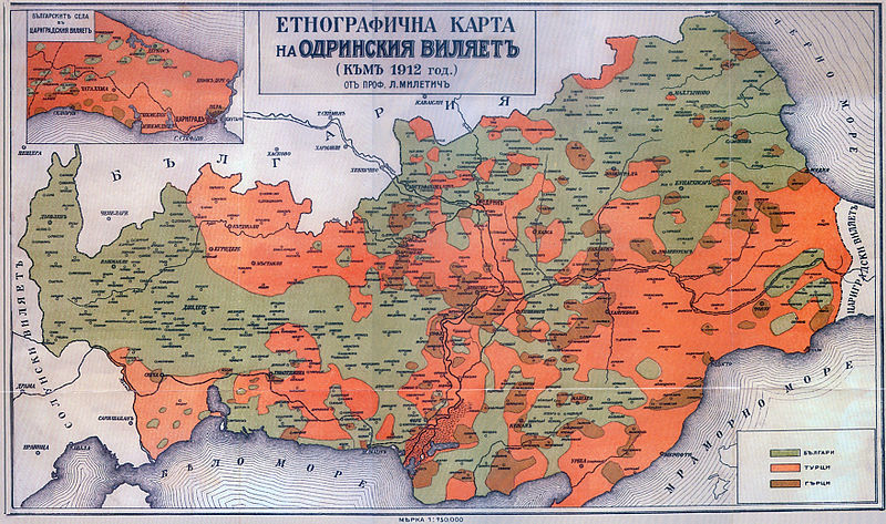
Български: Етнографска карта на Одрински вилает (Източна и Западна Тракия) на Любомир Милетич от 1861. English: Ethnographic map of Edirne Villayet (en:Eastern Thrace and en:Western Thrace) in 1912 by en:Lyubomir Miletich. |
| Zdroj | Разорението на тракийските българи през 1913 година, Българска академия на науките, София, Държавна печатница, 1918 г. |
| Autor | bg:Любомир Милетич, en:Lyubomir Miletich (1863-1937) |
Licence
|
Toto dílo je volné také v zemích, jejichž právní řád chrání majetková autorská práva po dobu života autora a 70 let po jeho smrti.
| |
| Bylo zjištěno, že u tohoto souboru nejsou známa žádná omezení daná autorským právem a právy s ním souvisejícími. | |
Historie souboru
Kliknutím na datum a čas se zobrazí tehdejší verze souboru.
| Datum a čas | Náhled | Rozměry | Uživatel | Komentář | |
|---|---|---|---|---|---|
| současná | 20. 1. 2013, 21:07 | | 3 520 × 2 080 (6,01 MB) | Slick-o-bot | Bot: convert to a non-interlaced jpeg image (see bugzilla:17645) |
| 22. 3. 2008, 12:55 |  | 3 520 × 2 080 (4,98 MB) | Пакко | {{Information |Description= |Source= |Date= |Author= |Permission= |other_versions= }} | |
| 8. 1. 2008, 11:12 |  | 3 520 × 2 080 (2,17 MB) | Мико | {{Information |Description={{bg|Етнографска карта на Одрински вилает (Източна и Западна Тракия на [[:bg:Любомир Милетич|Люб� |
Využití souboru
Tento soubor používá následující stránka:
Globální využití souboru
Tento soubor využívají následující wiki:
- Využití na ast.wikipedia.org
- Využití na ba.wikipedia.org
- Využití na be-tarask.wikipedia.org
- Využití na be.wikipedia.org
- Využití na bg.wikipedia.org
- Využití na ca.wikipedia.org
- Využití na de.wikipedia.org
- Využití na en.wikipedia.org
- Využití na es.wikipedia.org
- Využití na fr.wikipedia.org
- Využití na hy.wikipedia.org
- Využití na it.wikipedia.org
- Využití na ka.wikipedia.org
- Využití na mk.wikipedia.org
- Využití na myv.wikipedia.org
- Využití na oc.wikipedia.org
- Využití na ru.wikipedia.org
- Využití na sq.wikipedia.org
- Využití na tr.wikipedia.org
- Využití na uk.wikipedia.org