
Soubor:Bahnstrecke Ostrov nad Ohří–Jáchymov.png

Velikost tohoto náhledu: 313 × 600 pixelů. Jiná rozlišení: 125 × 240 pixelů | 250 × 480 pixelů | 640 × 1 226 pixelů.
Původní soubor (640 × 1 226 pixelů, velikost souboru: 375 KB, MIME typ: image/png)
| Tento soubor pochází z Wikimedia Commons. Níže jsou zobrazeny informace, které obsahuje jeho tamější stránka s popisem souboru. |
Popis
| Popis |
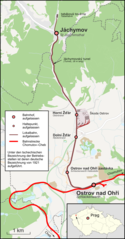
Deutsch: Karte der Bahnstrecke Ostrov nad Ohří–Jáchymov in Tschechien |
| Datum | |
| Zdroj |
Vlastní dílo Map was created using:
|
| Autor | |
| Svolení (Užití tohoto souboru) |
Map data (c) OpenStreetMap (and) contributors, CC-BY-SA |
Licence
Tento soubor podléhá licenci Creative Commons Uveďte autora-Zachovejte licenci 2.0 Generic
- Dílo smíte:
- šířit – kopírovat, distribuovat a sdělovat veřejnosti
- upravovat – pozměňovat, doplňovat, využívat celé nebo částečně v jiných dílech
- Za těchto podmínek:
- uveďte autora – Máte povinnost uvést autorství, poskytnout odkaz na licenci a uvést, pokud jste provedli změny. Toho můžete docílit jakýmkoli rozumným způsobem, avšak ne způsobem naznačujícím, že by poskytovatel licence schvaloval nebo podporoval vás nebo vaše užití díla.
- zachovejte licenci – Pokud tento materiál jakkoliv upravíte, přepracujete nebo použijete ve svém díle, musíte své příspěvky šířit pod stejnou nebo slučitelnou licencí jako originál.
Historie souboru
Kliknutím na datum a čas se zobrazí tehdejší verze souboru.
| Datum a čas | Náhled | Rozměry | Uživatel | Komentář | |
|---|---|---|---|---|---|
| současná | 19. 2. 2022, 20:04 | | 640 × 1 226 (375 KB) | Pechristener | Gleise bei der Skoda-Halle anders |
| 6. 3. 2015, 20:53 |  | 683 × 1 308 (402 KB) | Pechristener | Jáchymovský tunel (Akzent gesetzt) | |
| 6. 3. 2015, 00:31 |  | 683 × 1 308 (402 KB) | Pechristener | Wald um Joachimstal korr | |
| 6. 3. 2015, 00:04 |  | 683 × 1 308 (401 KB) | Pechristener | Bezeichnung ''Jáchymovsky tunel'' entfernt / Schlackenwerth H durch Schlackenwerth Haltestelle ersetzt / Karte in der Höhe gekürzt | |
| 5. 3. 2015, 23:31 |  | 683 × 1 466 (428 KB) | Pechristener | Bemerkung bzgl der verwendeten deutschen Bezeichnungen in der Legende der Karte hinzugefügt. | |
| 5. 3. 2015, 21:56 |  | 683 × 1 466 (420 KB) | Pechristener | die "Löcher" in der Hauptstrecke beseitigt | |
| 5. 3. 2015, 21:47 |  | 683 × 1 466 (423 KB) | Pechristener | Legende hinzu / Farbe der Strecken geändert / Deutsche Namen von 1921 eingesetzt | |
| 4. 3. 2015, 15:32 |  | 683 × 1 466 (423 KB) | Pechristener | Location map fixed | |
| 4. 3. 2015, 15:30 |  | 683 × 1 466 (422 KB) | Pechristener | == {{int:filedesc}} == {{Information |Description = {{de|1=Karte der Bahnstrecke Ostrov nad Ohří–Jáchymov in Tschechien}} |Source ={{own}} Map was created using: *[http://www.openst... |
Využití souboru
Tento soubor používá následující stránka:
Globální využití souboru
Tento soubor využívají následující wiki:
- Využití na de.wikipedia.org
- Využití na pl.wikipedia.org
- Využití na www.wikidata.org