
Soubor:Satellite image of Flevopolder, Netherlands (5.48E 52.43N).png

Velikost tohoto náhledu: 800 × 548 pixelů. Jiná rozlišení: 320 × 219 pixelů | 640 × 439 pixelů | 1 024 × 702 pixelů.
Původní soubor (1 024 × 702 pixelů, velikost souboru: 1,49 MB, MIME typ: image/png)
| Tento soubor pochází z Wikimedia Commons. Níže jsou zobrazeny informace, které obsahuje jeho tamější stránka s popisem souboru. |
.png)
| Popis |
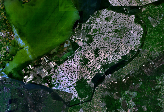
English: Satellite image of the Flevopolder in the Netherlands. Technically, the Flevopolder consists of Zuidelijk Flevoland (Southern Flevoland), Oostelijk Flevoland (Eastern Flevoland) and the Noordoostpolder (North Eastern Polder). This image shows Southern and Eastern Flevoland. |
| Zdroj | Screenshot from NASA's World Wind |
| Autor | Fotografie: NASA |
| This image is in the public domain because it is a screenshot from NASA’s globe software World Wind using a public domain layer, such as Blue Marble, MODIS, Landsat, SRTM, USGS or GLOBE.
|
 |
Historie souboru
Kliknutím na datum a čas se zobrazí tehdejší verze souboru.
| Datum a čas | Náhled | Rozměry | Uživatel | Komentář | |
|---|---|---|---|---|---|
| současná | 4. 5. 2005, 15:25 | | 1 024 × 702 (1,49 MB) | Galwaygirl | Satellite image of the Flevopolder in the Netherlands. Screenshot from NASA's World Wind {{PD}} |
Využití souboru
Tento soubor používá následujících 5 stránek:
Globální využití souboru
Tento soubor využívají následující wiki:
- Využití na an.wikipedia.org
- Využití na ar.wikipedia.org
- Využití na ast.wikipedia.org
- Využití na br.wikipedia.org
- Využití na ca.wikipedia.org
- Využití na da.wikipedia.org
- Využití na de.wikipedia.org
- Využití na el.wikipedia.org
- Využití na en.wikipedia.org
- Využití na es.wikipedia.org
- Využití na eu.wikipedia.org
- Využití na fa.wikipedia.org
- Využití na fr.wikipedia.org
- Využití na gl.wikipedia.org
- Využití na he.wikipedia.org
- Využití na hr.wikipedia.org
- Využití na hy.wikipedia.org
- Využití na id.wikipedia.org
- Využití na kk.wikipedia.org
- Využití na ko.wikipedia.org
- Využití na ms.wikipedia.org
- Využití na nl.wikipedia.org
- Flevoland
- Hoofdpagina
- Oostelijk Flevoland
- Zuidelijk Flevoland
- Flevopolder
- Sjabloon:Hoofdpagina
- Gebruiker:Evil berry/Hoofdpagina
- Wikipedia:Sjablonen van de hoofdpagina
- Portaal:Hoofdpagina (mobiel)
- Gebruiker:FranklyMyDear.../Hoofdpagina
- Gebruiker:Dinosaur918/Hoofdpagina
- Gebruiker:Olivier Bommel/dingen2
- Gebruiker:Meerrie/Kladblok
- Gebruiker:DirkVE/Hoofdpagina
- Wikipedia:Wikiproject/Wist je dat/Sjablonen/Mei
- Sjabloon:Hoofdpagina - wist je dat 20 mei
- Wikipedia:Hoofdpagina (oud, 2007-2015)
- Gebruiker:Opzoeken/Replica van de hoofdpagina
- Gebruiker:Sakretsu/Kladblok
Zobrazit další globální využití tohoto souboru.
.png)
.png)