
Soubor:Naturraeumliche Grossregionen Deutschlands plus.png

Velikost tohoto náhledu: 472 × 599 pixelů. Jiná rozlišení: 189 × 240 pixelů | 378 × 480 pixelů | 605 × 768 pixelů | 807 × 1 024 pixelů | 1 827 × 2 318 pixelů.
Původní soubor (1 827 × 2 318 pixelů, velikost souboru: 6,48 MB, MIME typ: image/png)
| Tento soubor pochází z Wikimedia Commons. Níže jsou zobrazeny informace, které obsahuje jeho tamější stránka s popisem souboru. |
Popis
| Popis |
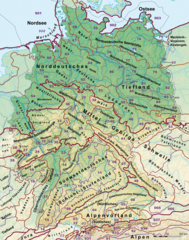
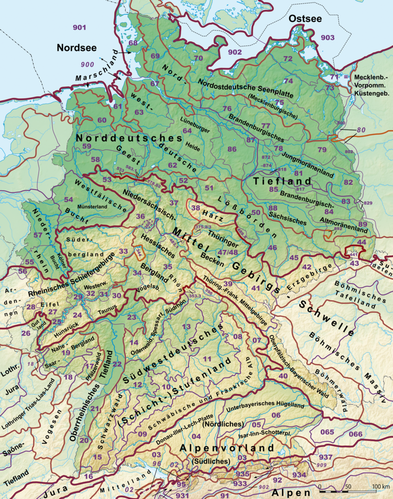
Deutsch: Karte der Naturräumlichen Großregionen Deutschlands
Legende
|
| Zdroj | |
| Autor |
|
| Další verze |
Díla odvozená od tohoto souboru:
Ausschnittskarten: 1000 px breit
Andere Breiten
|


.png)

Licence
Já, držitel autorských práv k tomuto dílu, ho tímto zveřejňuji za podmínek následujících licencí:

|
Tento dokument smí být kopírován, šířen nebo upravován podle podmínek Svobodné licence GNU pro dokumenty verze 1.2 nebo libovolné vyšší verze publikované nadací Free Software Foundation. Dokument nemá neměnné části ani texty na předním či zadním přebalu. Kopie textu licence je k dispozici v oddíle nazvaném GNU Free Documentation License. |
Tento soubor podléhá licenci Creative Commons Uveďte autora-Zachovejte licenci 3.0 Unported
- Dílo smíte:
- šířit – kopírovat, distribuovat a sdělovat veřejnosti
- upravovat – pozměňovat, doplňovat, využívat celé nebo částečně v jiných dílech
- Za těchto podmínek:
- uveďte autora – Máte povinnost uvést autorství, poskytnout odkaz na licenci a uvést, pokud jste provedli změny. Toho můžete docílit jakýmkoli rozumným způsobem, avšak ne způsobem naznačujícím, že by poskytovatel licence schvaloval nebo podporoval vás nebo vaše užití díla.
- zachovejte licenci – Pokud tento materiál jakkoliv upravíte, přepracujete nebo použijete ve svém díle, musíte své příspěvky šířit pod stejnou nebo slučitelnou licencí jako originál.
Můžete si zvolit libovolnou z těchto licencí.
Historie souboru
Kliknutím na datum a čas se zobrazí tehdejší verze souboru.
| Datum a čas | Náhled | Rozměry | Uživatel | Komentář | |
|---|---|---|---|---|---|
| současná | 24. 12. 2020, 00:36 | | 1 827 × 2 318 (6,48 MB) | Elop | |
| 23. 12. 2020, 23:07 |  | 1 827 × 2 318 (6,48 MB) | Elop | ||
| 25. 12. 2014, 20:53 |  | 1 827 × 2 318 (6,53 MB) | Elop | Lößbörden korr. (533), insbesondere Grenzverlauf; Vorland des Thüringer Waldes (380) strittige Naturräume mit Nummern | |
| 22. 11. 2014, 15:42 |  | 1 827 × 2 318 (6,52 MB) | Elop | Korrekturen im Norden: Statt "Ems-Weser-Geest" und "Nordelbische Geest" zusammenfassend "Norddeutsche"; Lüneheide und Meckerplatte als sehr bekannte Landschaften beschriftet; dicke Linie zwischen Erst- und Zweitgenannter gedünnt, Außenlinie von 87 a... | |
| 2. 7. 2012, 15:46 |  | 1 827 × 2 318 (6,52 MB) | Elop | k | |
| 1. 7. 2012, 23:29 |  | 1 827 × 2 318 (6,52 MB) | Elop | k | |
| 1. 7. 2012, 17:08 |  | 1 827 × 2 318 (6,52 MB) | Elop | k | |
| 1. 7. 2012, 00:44 |  | 1 827 × 2 318 (6,49 MB) | Elop | Update; insbesondere Alpen komplett neu; alle Pfade neu nachgezeichnet und korrigiert, auch außerhalb Dlands; NNWs Karte damit vektoriell erneuert | |
| 27. 5. 2012, 16:31 |  | 1 827 × 2 318 (6,5 MB) | Elop | Update | |
| 25. 10. 2011, 02:25 |  | 1 827 × 2 318 (6,49 MB) | Elop | k |
Využití souboru
Tento soubor používá následující stránka:
Globální využití souboru
Tento soubor využívají následující wiki:
- Využití na de.wikipedia.org
- Mittelgebirge
- Norddeutsches Tiefland
- Liste der Landschaften in Bayern
- Mittelgebirgsschwelle
- Naturräume in Sachsen
- Naturräumliche Großregionen Deutschlands
- Naturraum
- Portal:Umwelt- und Naturschutz/Artikel des Monats
- Diskussion:Mitteldeutschland/Archiv/1
- Benutzer:Frze
- Benutzer Diskussion:Elop/Archiv 2011
- Wikipedia:WikiProjekt Geographie/Projekt Naturräumliche Gliederung Mitteleuropas
- Vorlage:Positionskarte Deutschland Naturraum
- Vorlage Diskussion:Positionskarte Deutschland Naturraum
- Benutzer:Elop/Galerie/Karten
- Nordbrandenburgisches Platten- und Hügelland
- Mittelbrandenburgische Platten und Niederungen
- Využití na en.wikipedia.org
- Využití na es.wikipedia.org
- Využití na fr.wikipedia.org
- Využití na no.wikipedia.org
- Využití na pl.wikipedia.org
- Využití na ru.wikipedia.org
- Využití na sl.wikipedia.org
- Využití na www.wikidata.org