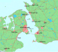
Soubor:Map of Öresund between Denmark and Sweden.png

Velikost tohoto náhledu: 666 × 600 pixelů. Jiná rozlišení: 267 × 240 pixelů | 533 × 480 pixelů | 924 × 832 pixelů.
Původní soubor (924 × 832 pixelů, velikost souboru: 205 KB, MIME typ: image/png)
Historie souboru
Kliknutím na datum a čas se zobrazí tehdejší verze souboru.
| Datum a čas | Náhled | Rozměry | Uživatel | Komentář | |
|---|---|---|---|---|---|
| současná | 29. 6. 2006, 02:04 |  | 924 × 832 (205 KB) | Thuresson | larger |
| 26. 6. 2006, 02:57 |  | 397 × 441 (72 KB) | Thuresson | +Köpenhamn | |
| 26. 6. 2006, 02:50 |  | 397 × 441 (71 KB) | Thuresson | Map of Öresund between Denmark and Sweden. This map from demis.nl was slightly improved by User:Thuresson {{PD-Demis}} Category:Skåne Category:Zealand Category:Amager |
Využití souboru
Tento soubor používá následující stránka:
Globální využití souboru
Tento soubor využívají následující wiki:
- Využití na af.wikipedia.org
- Využití na az.wiktionary.org
- Využití na be-tarask.wikipedia.org
- Využití na de.wikipedia.org
- Využití na en.wikipedia.org
- Využití na es.wikipedia.org
- Využití na fi.wikipedia.org
- Využití na fi.wikinews.org
- Využití na la.wikipedia.org
- Využití na no.wikipedia.org
- Využití na ro.wikipedia.org
- Využití na sco.wikipedia.org
- Využití na sh.wikipedia.org
- Využití na sk.wikipedia.org
- Využití na sv.wikipedia.org
- Využití na th.wikipedia.org
