
Soubor:Generalgouvernement fur die besetzten polnischen gebiete.png

Velikost tohoto náhledu: 556 × 599 pixelů. Jiná rozlišení: 223 × 240 pixelů | 445 × 480 pixelů | 713 × 768 pixelů | 950 × 1 024 pixelů | 1 610 × 1 735 pixelů.
Původní soubor (1 610 × 1 735 pixelů, velikost souboru: 523 KB, MIME typ: image/png)
| Tento soubor pochází z Wikimedia Commons. Níže jsou zobrazeny informace, které obsahuje jeho tamější stránka s popisem souboru. |
Popis
| Popis |
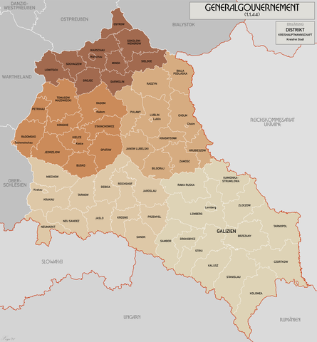
English: Administrative map of the Generalgouvernement für die besetzten polnischen Gebiete. |
| Datum | |
| Zdroj | Vlastní dílo |
| Autor | XrysD |
| Další verze | File:General Government for the occupied Polish territories.png |
Licence
Já, držitel autorských práv k tomuto dílu, ho tímto zveřejňuji za podmínek následujících licencí:
Tento soubor podléhá licenci Creative Commons Uveďte autora-Zachovejte licenci 3.0 Unported
- Dílo smíte:
- šířit – kopírovat, distribuovat a sdělovat veřejnosti
- upravovat – pozměňovat, doplňovat, využívat celé nebo částečně v jiných dílech
- Za těchto podmínek:
- uveďte autora – Máte povinnost uvést autorství, poskytnout odkaz na licenci a uvést, pokud jste provedli změny. Toho můžete docílit jakýmkoli rozumným způsobem, avšak ne způsobem naznačujícím, že by poskytovatel licence schvaloval nebo podporoval vás nebo vaše užití díla.
- zachovejte licenci – Pokud tento materiál jakkoliv upravíte, přepracujete nebo použijete ve svém díle, musíte své příspěvky šířit pod stejnou nebo slučitelnou licencí jako originál.

|
Tento dokument smí být kopírován, šířen nebo upravován podle podmínek Svobodné licence GNU pro dokumenty verze 1.2 nebo libovolné vyšší verze publikované nadací Free Software Foundation. Dokument nemá neměnné části ani texty na předním či zadním přebalu. Kopie textu licence je k dispozici v oddíle nazvaném GNU Free Documentation License. |
Můžete si zvolit libovolnou z těchto licencí.
Historie souboru
Kliknutím na datum a čas se zobrazí tehdejší verze souboru.
| Datum a čas | Náhled | Rozměry | Uživatel | Komentář | |
|---|---|---|---|---|---|
| současná | 17. 10. 2021, 12:11 | | 1 610 × 1 735 (523 KB) | XrysD | Incorporated typos KRUBIESZOW->HRUBIESZOW and CZORTZOW->CZORTKOW |
| 11. 10. 2021, 20:12 |  | 1 610 × 1 735 (575 KB) | Kamilhrub | Czortzow → Czortkow | |
| 6. 10. 2021, 12:30 |  | 1 610 × 1 735 (575 KB) | Kamilhrub | Corrected name Hrubieszow and southern borders of Bilgoraj, Hrubieszow and Zamosc districts, which didn't change after 1941 (source: Amtliches Gemeinde- und Dorfverzeichnis für das Generalgouvernement auf Grund der Summarischen Bevölkerungsbestandsaufnahme am 1. März 1943) | |
| 8. 5. 2015, 11:41 |  | 1 610 × 1 735 (438 KB) | RokerHRO | optipng -o7 -i0 → 21.79% decrease | |
| 19. 4. 2015, 12:36 |  | 1 610 × 1 735 (560 KB) | XrysD | Komplett neue Karte. Grundkarte: Karte des Deutschen Reiches 1:100k, Karte von Mitteleuropa 1:300k, Mapa Administracyjna Rzeczypospolitej Polska 1:300k (Quelle mapyWIG). | |
| 27. 5. 2012, 18:18 |  | 2 299 × 2 280 (398 KB) | XrysD | Fixed typos | |
| 26. 5. 2012, 21:51 |  | 2 299 × 2 280 (396 KB) | XrysD | Changed version to all German Language. Changed all colours to use Bartholomew set. English language version can now be found under File:General Government for the occupied Polish territories.png | |
| 26. 5. 2012, 21:45 |  | 2 299 × 2 280 (396 KB) | XrysD | Changed version to all German Language. Changed all colours to use Bartholomew set. English language version can now be found under File:General Government for the occupied Polish territories.png | |
| 23. 1. 2009, 22:38 |  | 2 299 × 2 280 (391 KB) | XrysD | {{Information |Description= |Source= |Date= |Author= |Permission= |other_versions= }} | |
| 29. 11. 2008, 21:36 |  | 2 299 × 2 279 (367 KB) | XrysD | {{Information |Description={{en|1=Administrative map of the Generalgouvernement für die besetzten polnischen Gebiete.}} |Source=Own work by uploader |Author=XrysD |Date=29/11/2008 |Permission= |other_versions= }} <!--{{ImageUpload|full}}- |
Využití souboru
Tento soubor používá následující stránka:
Globální využití souboru
Tento soubor využívají následující wiki:
- Využití na ar.wikipedia.org
- Využití na ast.wikipedia.org
- Využití na ba.wikipedia.org
- Využití na be-tarask.wikipedia.org
- Využití na ca.wikipedia.org
- Využití na de.wikipedia.org
- Využití na el.wikipedia.org
- Využití na es.wikipedia.org
- Využití na fi.wikipedia.org
- Využití na fr.wikipedia.org
- Využití na fr.wiktionary.org
- Využití na gl.wikipedia.org
- Využití na hu.wikipedia.org
- Využití na it.wikipedia.org
- Využití na sh.wikipedia.org
- Využití na simple.wikipedia.org
- Využití na sr.wikipedia.org
- Využití na sv.wikipedia.org
- Využití na uk.wikipedia.org
- Využití na www.wikidata.org
- Využití na zh.wikipedia.org