
Soubor:Cordyline-australis-ecotype.png
Velikost tohoto náhledu: 475 × 599 pixelů. Jiná rozlišení: 190 × 240 pixelů | 380 × 480 pixelů | 609 × 768 pixelů | 812 × 1 024 pixelů | 2 000 × 2 523 pixelů.
Původní soubor (2 000 × 2 523 pixelů, velikost souboru: 215 KB, MIME typ: image/png)
| Tento soubor pochází z Wikimedia Commons. Níže jsou zobrazeny informace, které obsahuje jeho tamější stránka s popisem souboru. |
| Popis |
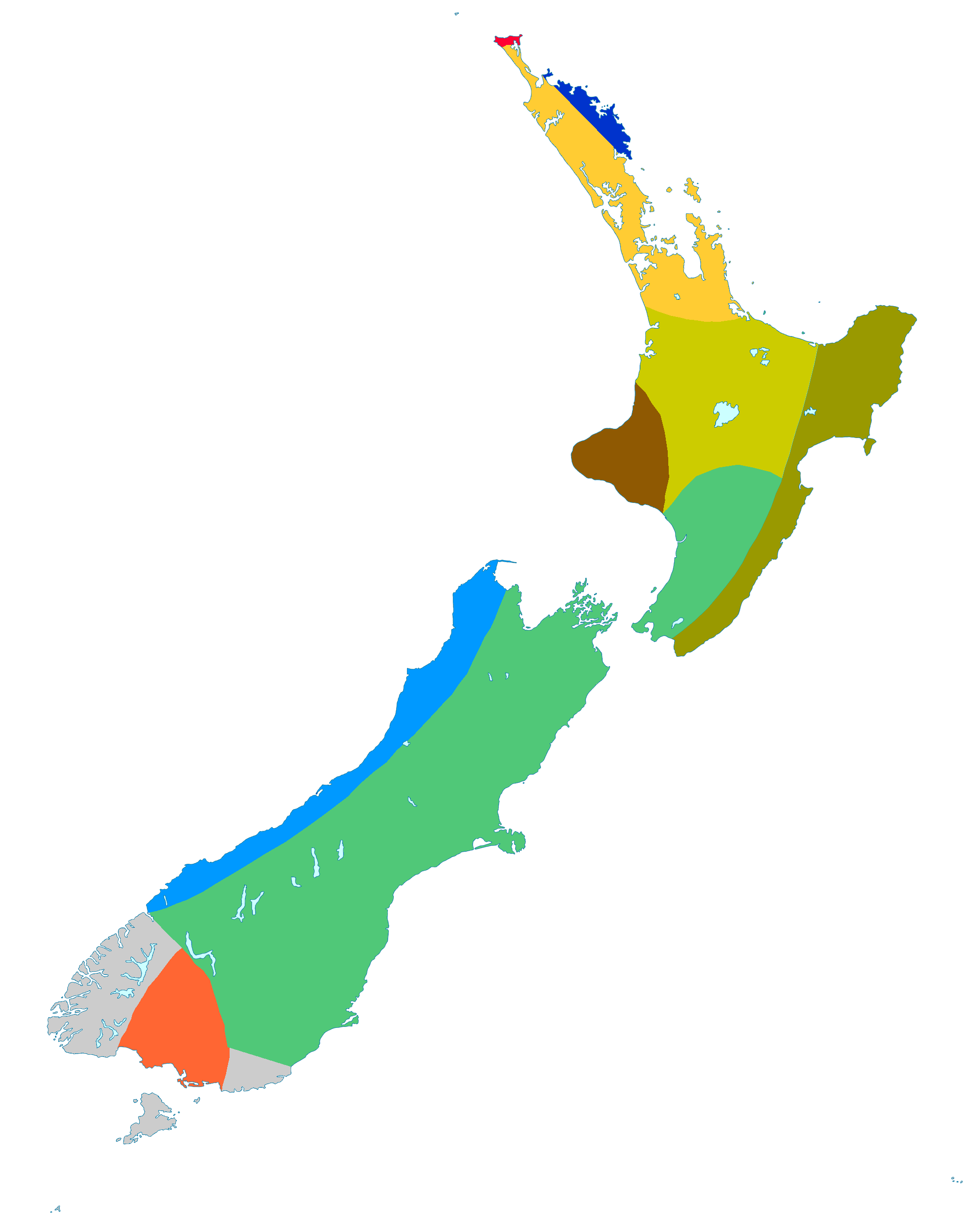
Distribution map showing ecotypes (regional variants) of Cordyline australis, Cabbage tree, endemic to New Zealand. Possible hybridisation with C. pumilio. Leaves floppy. North Cape
Possible hybridisation with C. obtecta. Leaves straight, dark green, narrow. Eastern Northland
Spindly trees with short broad leaves: Māori name Tītī. Northland and Auckland
Robust trees with straight broad leaves, few branches: Māori name Tī manu. Central North Island
Leaves narrow throughout, but lax in north, stiff in south: Māori name Tarariki. East Coast of the North Island
Compact, densely branched trees. Taranaki
Leaves long, relatively broad, flexible: Māori name Wharanui. Southern North Island (west of main divide), South Island (east of main divide)
Robust trees with bluish leaves on the coast; tall trees with narrow, green leaves on river flats. South Island West Coast
Robust trees with broad, lax leaves. Southland
C. australis naturally absent. Catlins, Fiordland, Stewart Island
Cordyline australis, the Cabbage tree is a tree endemic to New Zealand. Map based on Simpson, P. (2000). Dancing Leaves: The story of the New Zealand cabbage tree: Tī Kōuka. Christchurch: Canterbury University Press. p. 71. |
| Datum | |
| Zdroj | File:New Zealand location map transparent.svg adapted by uploader User:Kahuroa |
| Autor | Kahuroa |
Licence
| Kahuroa, autor tohoto díla, jej uvolnil jako volné dílo, a to celosvětově. V některých zemích to není podle zákona možné; v takovém případě: |
Historie souboru
Kliknutím na datum a čas se zobrazí tehdejší verze souboru.
| Datum a čas | Náhled | Rozměry | Uživatel | Komentář | |
|---|---|---|---|---|---|
| současná | 14. 9. 2010, 09:49 | | 2 000 × 2 523 (215 KB) | Kahuroa | swap two more |
| 14. 9. 2010, 09:38 |  | 2 000 × 2 523 (215 KB) | Kahuroa | swap two colours for each other (northland and eastern northland) | |
| 14. 9. 2010, 09:30 |  | 2 000 × 2 523 (214 KB) | Kahuroa | More distinct colours | |
| 2. 5. 2010, 11:59 |  | 2 000 × 2 523 (390 KB) | Kahuroa | blur edges a bit | |
| 1. 5. 2010, 08:43 |  | 2 000 × 2 523 (211 KB) | Kahuroa | GRey to cccccc | |
| 1. 5. 2010, 06:08 |  | 2 000 × 2 523 (211 KB) | Kahuroa | Colour mostly green shades | |
| 27. 4. 2010, 07:51 |  | 2 000 × 2 523 (210 KB) | Kahuroa | lose the sea | |
| 26. 4. 2010, 13:41 |  | 2 000 × 2 523 (177 KB) | Kahuroa | Colour changes - using colours the French use (but there is no standard for this sort of map yet) | |
| 24. 4. 2010, 11:53 |  | 2 000 × 2 523 (210 KB) | Kahuroa | Remove artifacts | |
| 22. 4. 2010, 07:24 |  | 2 000 × 2 523 (210 KB) | Kahuroa | Minor tidy up - cleaner background |
Využití souboru
Tento soubor používá následující stránka:
Globální využití souboru
Tento soubor využívají následující wiki:
- Využití na ar.wikipedia.org
- Využití na arz.wikipedia.org
- Využití na ast.wikipedia.org
- Využití na ca.wikipedia.org
- Využití na ceb.wikipedia.org
- Využití na en.wikipedia.org
- Využití na es.wikipedia.org
- Využití na eu.wikipedia.org
- Využití na fa.wikipedia.org
- Využití na fr.wikipedia.org
- Využití na hu.wikipedia.org
- Využití na id.wikipedia.org
- Využití na it.wikipedia.org
- Využití na ja.wikipedia.org
- Využití na nn.wikipedia.org
- Využití na pt.wikipedia.org
- Využití na sv.wikipedia.org
- Využití na vi.wikipedia.org
- Využití na www.wikidata.org
- Využití na zh-yue.wikipedia.org