
Soubor:Cisleithania, Lands of the Crown of Saint Stephen, Bosnia and Herzegovina.svg

Velikost tohoto PNG náhledu tohoto SVG souboru: 776 × 600 pixelů. Jiná rozlišení: 311 × 240 pixelů | 621 × 480 pixelů | 994 × 768 pixelů | 1 280 × 989 pixelů | 2 560 × 1 978 pixelů | 783 × 605 pixelů.
Původní soubor (soubor SVG, nominální rozměr: 783 × 605 pixelů, velikost souboru: 236 KB)
| Tento soubor pochází z Wikimedia Commons. Níže jsou zobrazeny informace, které obsahuje jeho tamější stránka s popisem souboru. |
Popis
| Popis |
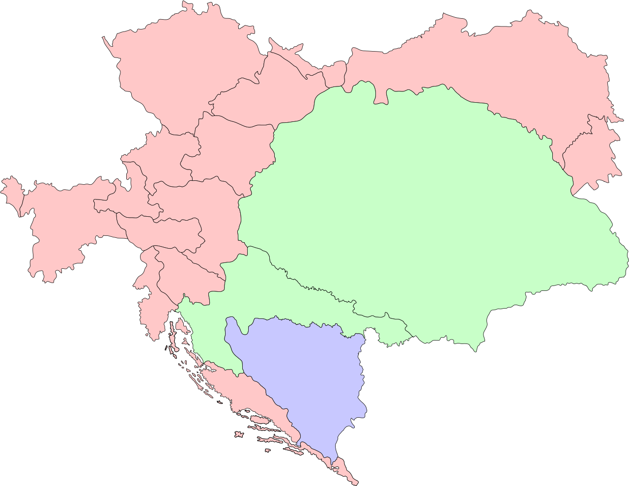
English: The map shows administrative division of Austria-Hungary. Cisleithania, governed by Austria, is shown in red; the Lands of the Crown of Saint Stephen, governed by Hungary, are shown in green; the Condominium of Bosnia and Herzegovina, which was governed by both, Austria and Hungary, is shown in blue. |
| Datum | |
| Zdroj | Vlastní dílo |
| Autor | Herr Ziffer |
Licence
Já, držitel autorských práv k tomuto dílu, ho tímto zveřejňuji za podmínek následujících licencí:
Tento soubor podléhá licenci Creative Commons Uveďte autora-Zachovejte licenci 3.0 Unported
- Dílo smíte:
- šířit – kopírovat, distribuovat a sdělovat veřejnosti
- upravovat – pozměňovat, doplňovat, využívat celé nebo částečně v jiných dílech
- Za těchto podmínek:
- uveďte autora – Máte povinnost uvést autorství, poskytnout odkaz na licenci a uvést, pokud jste provedli změny. Toho můžete docílit jakýmkoli rozumným způsobem, avšak ne způsobem naznačujícím, že by poskytovatel licence schvaloval nebo podporoval vás nebo vaše užití díla.
- zachovejte licenci – Pokud tento materiál jakkoliv upravíte, přepracujete nebo použijete ve svém díle, musíte své příspěvky šířit pod stejnou nebo slučitelnou licencí jako originál.

|
Tento dokument smí být kopírován, šířen nebo upravován podle podmínek Svobodné licence GNU pro dokumenty verze 1.2 nebo libovolné vyšší verze publikované nadací Free Software Foundation. Dokument nemá neměnné části ani texty na předním či zadním přebalu. Kopie textu licence je k dispozici v oddíle nazvaném GNU Free Documentation License. |
Můžete si zvolit libovolnou z těchto licencí.
Historie souboru
Kliknutím na datum a čas se zobrazí tehdejší verze souboru.
| Datum a čas | Náhled | Rozměry | Uživatel | Komentář | |
|---|---|---|---|---|---|
| současná | 28. 12. 2012, 19:20 | | 783 × 605 (236 KB) | Herr Ziffer | {{Information |Description ={{en|1=The map shows administrative division of Austria-Hungary. Cisleithania, governed by Austria, is shown in red; the [[w:Lands of the Crown of Saint Stephen|Lands of the Crown ... |
Využití souboru
Tento soubor používají následující 3 stránky:
Globální využití souboru
Tento soubor využívají následující wiki:
- Využití na ar.wikipedia.org
- Využití na azb.wikipedia.org
- Využití na bg.wikipedia.org
- Využití na de.wikipedia.org
- Reichsratswahl 1907
- Reichsratswahl 1911
- Reichsratswahl 1901
- Reichsratswahl 1897
- Parlamentswahl in Ungarn 1910
- Parlamentswahl in Ungarn 1906
- Parlamentswahl in Ungarn 1905
- Parlamentswahl in Ungarn 1901
- Parlamentswahl in Ungarn 1896
- Parlamentswahl in Ungarn 1892
- Parlamentswahl in Ungarn 1887
- Parlamentswahl in Ungarn 1884
- Parlamentswahl in Ungarn 1881
- Parlamentswahl in Ungarn 1878
- Parlamentswahl in Ungarn 1875
- Parlamentswahl in Ungarn 1872
- Parlamentswahl in Ungarn 1869
- Reichsratswahl 1891
- Reichsratswahl 1885
- Reichsratswahl 1879
- Reichsratswahl 1873
- Kondominium Bosnien und Herzegowina
- Reichsratswahl 1867
- Reichsratswahl 1870/71
- Využití na en.wikipedia.org
- Využití na es.wikipedia.org
- Využití na et.wikipedia.org
- Využití na fa.wikipedia.org
- Využití na fr.wikipedia.org
- Využití na fr.wiktionary.org
- Využití na he.wikipedia.org
- Využití na hr.wikipedia.org
Zobrazit další globální využití tohoto souboru.