
Soubor:BNR (Ruthienie Blanche) Map 1918.jpg

Původní soubor (4 400 × 3 015 pixelů, velikost souboru: 10,27 MB, MIME typ: image/jpeg)
| Tento soubor pochází z Wikimedia Commons. Níže jsou zobrazeny informace, které obsahuje jeho tamější stránka s popisem souboru. |
_Map_1918.jpg)
Popis
| Titul |
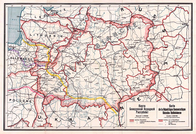
Беларуская: Карта Беларускай Народнай Рэспублікі, 1918 Беларуская (тарашкевіца): Мапа Беларускай Народнай Рэспублікі, 1918
English: Map of the territory claimed by the Belarusian People's Republic (published in 1918).
Русский: Карта Белорусской Народной Республики, 1918
Українська: Карта Білоруської Народної Республіки, 1918 |
| Datum | |
| Zdroj |
1. Карта БНР 1918 год, IMAGO.BY 2. Originally uploaded to English Wikipedia by Rydel (21:53, 2 January 2005) as en:Image:BNR ruthienie blanche.jpg. |
| Tvůrce |
Neznámý |
| Georeferencing | If inappropriate please set warp_status = skip to hide. |
Licence
|
Toto dílo je volné také v zemích, jejichž právní řád chrání majetková autorská práva po dobu života autora a 70 let po jeho smrti.
| |
| Bylo zjištěno, že u tohoto souboru nejsou známa žádná omezení daná autorským právem a právy s ním souvisejícími. | |
Historie souboru
Kliknutím na datum a čas se zobrazí tehdejší verze souboru.
| Datum a čas | Náhled | Rozměry | Uživatel | Komentář | |
|---|---|---|---|---|---|
| současná | 26. 10. 2017, 15:56 | | 4 400 × 3 015 (10,27 MB) | Kazimier Lachnovič | better quality |
| 3. 9. 2005, 16:18 |  | 1 000 × 700 (195 KB) | EugeneZelenko | Map of Belarusian National Republic (published in 1918). Originally uploaded to English Wikipedia by Rydel (21:53, 2 January 2005) as en:Image:BNR ruthienie blanche.jpg. Category:Historical maps of Belarus |
Využití souboru
Tento soubor používají následující 3 stránky:
Globální využití souboru
Tento soubor využívají následující wiki:
- Využití na ar.wikipedia.org
- Využití na ast.wikipedia.org
- Využití na be-tarask.wikipedia.org
- Využití na be.wikipedia.org
- Využití na bg.wikipedia.org
- Využití na ca.wikipedia.org
- Využití na cy.wikipedia.org
- Využití na da.wikipedia.org
- Využití na de.wikipedia.org
- Využití na en.wikipedia.org
- Využití na eo.wikipedia.org
- Využití na es.wikipedia.org
- Využití na et.wikipedia.org
- Využití na eu.wikipedia.org
- Využití na fr.wikipedia.org
- Využití na hu.wikipedia.org
- Využití na it.wikipedia.org
- Využití na lt.wikipedia.org
Zobrazit další globální využití tohoto souboru.
_Map_1918.jpg)
_Map_1918.jpg)