
Soubor:Antarctic Peninsula, the Larsen Ice Shelf, and the sea ice covered waters around the region.jpg

Velikost tohoto náhledu: 468 × 599 pixelů. Jiná rozlišení: 187 × 240 pixelů | 375 × 480 pixelů | 600 × 768 pixelů | 800 × 1 024 pixelů | 1 600 × 2 048 pixelů | 5 000 × 6 400 pixelů.
Původní soubor (5 000 × 6 400 pixelů, velikost souboru: 4,51 MB, MIME typ: image/jpeg)
| Tento soubor pochází z Wikimedia Commons. Níže jsou zobrazeny informace, které obsahuje jeho tamější stránka s popisem souboru. |
Popis
| Popis |
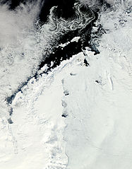
English: Clear view of the Antarctic Peninsula, the Larsen Ice Shelf, and the sea ice covered waters around the region. The Peninsula stands out as the raised terrain amidst the ice from the lower left to upper middle of the image. |
| Datum | |
| Zdroj | NASA Earth Observatory |
| Autor | Jeff Schmaltz |
Image captured by the Moderate Resolution Imaging Spectroradiometer (MODIS) on NASA’s Aqua satellite. NASA image provided courtesy of the MODIS Rapid Response team.
Licence
| This file is in the public domain in the United States because it was solely created by NASA. NASA copyright policy states that "NASA material is not protected by copyright unless noted". (See Template:PD-USGov, NASA copyright policy page or JPL Image Use Policy.) | ||
 |
Warnings:
|
| Poznámky | K tomuto souboru existují poznámky: Prohlédnout si poznámky na Commons |
Historie souboru
Kliknutím na datum a čas se zobrazí tehdejší verze souboru.
| Datum a čas | Náhled | Rozměry | Uživatel | Komentář | |
|---|---|---|---|---|---|
| současná | 17. 10. 2011, 14:15 | | 5 000 × 6 400 (4,51 MB) | Originalwana | {{Information |Description ={{en|1=Clear view of the Antarctic Peninsula, the Larsen Ice Shelf, and the sea ice covered waters around the region. The Peninsula stands out as the raised terrain amidst the ice from the lower left to upper middle of t |
Využití souboru
Tento soubor používá následující stránka:
Globální využití souboru
Tento soubor využívají následující wiki:
- Využití na ar.wikipedia.org
- Využití na en.wikipedia.org
- Využití na fa.wikipedia.org
- Využití na ko.wikipedia.org
- Využití na la.wikipedia.org
- Využití na mk.wikipedia.org
- Využití na ms.wikipedia.org
- Využití na nn.wikipedia.org
- Využití na pl.wikipedia.org
- Využití na pt.wikipedia.org
- Využití na ta.wikipedia.org
- Využití na uk.wikipedia.org
- Využití na zh.wikipedia.org